


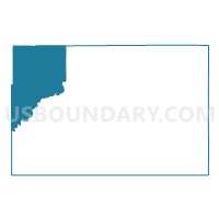
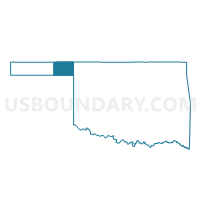
Voting District 33, Beaver County, Oklahoma
About
Outline

Summary
| Unique Area Identifier | 653499 |
| Name | Voting District 33 |
| County | Beaver County |
| State | Oklahoma |
| Area (square miles) | 227.92 |
| Land Area (square miles) | 227.89 |
| Water Area (square miles) | 0.03 |
| % of Land Area | 99.99 |
| % of Water Area | 0.01 |
| Latitude of the Internal Point | 36.87045700 |
| Longtitude of the Internal Point | -100.84638990 |
Maps

Graphs
Select a template below for downloading or customizing gragh for Voting District 33, Beaver County, Oklahoma


Neighbors
Neighoring Voting District (by Name) Neighboring Voting District on the Map
- Voting District 104, Texas County, OK
- Voting District 105, Texas County, OK
- Voting District 106, Texas County, OK
- Voting District 107, Texas County, OK
- Voting District 23, Beaver County, OK
- Voting District 26, Beaver County, OK
- Voting District 31, Beaver County, OK
- Fargo Township 1 Voting District, Seward County, KS
- Liberal Township 5 Voting District, Seward County, KS
Top 10 Neighboring County Subdivision (by Population) Neighboring County Subdivision on the Map
- Guymon CCD, Texas County, OK (15,235)
- Hooker CCD, Texas County, OK (3,790)
- South Beaver CCD, Beaver County, OK (2,938)
- North Beaver CCD, Beaver County, OK (2,698)
- Fargo township, Seward County, KS (1,563)
- Liberal township, Seward County, KS (548)
Top 10 Neighboring Place (by Population) Neighboring Place on the Map
Top 10 Neighboring Unified School District (by Population) Neighboring Unified School District on the Map
- Liberal Unified School District 480, KS (21,038)
- Kismet-Plains Unified School District 483, KS (3,175)
- Hooker Public Schools, OK (2,526)
- Turpin Public Schools, OK (1,978)
- Beaver Public Schools, OK (1,876)
- Forgan Public Schools, OK (784)
- Balko Public Schools, OK (720)
Top 10 Neighboring State Legislative District Lower Chamber (by Population) Neighboring State Legislative District Lower Chamber on the Map
Top 10 Neighboring State Legislative District Upper Chamber (by Population) Neighboring State Legislative District Upper Chamber on the Map
Top 10 Neighboring 111th Congressional District (by Population) Neighboring 111th Congressional District on the Map
Top 10 Neighboring Census Tract (by Population) Neighboring Census Tract on the Map
- Census Tract 9659, Seward County, KS (6,803)
- Census Tract 9506, Texas County, OK (3,790)
- Census Tract 9507, Texas County, OK (3,173)
- Census Tract 9516, Beaver County, OK (2,698)
- Census Tract 9656, Seward County, KS (2,397)
- Census Tract 9517, Beaver County, OK (1,327)
Top 10 Neighboring 5-Digit ZIP Code Tabulation Area (by Population) Neighboring 5-Digit ZIP Code Tabulation Area on the Map
- 67901, KS (22,073)
- 73945, OK (2,889)
- 73932, OK (2,092)
- 73950, OK (1,736)
- 73951, OK (1,141)
- 73938, OK (781)
- 73931, OK (510)
- 73944, OK (388)
- 73901, OK (156)